|
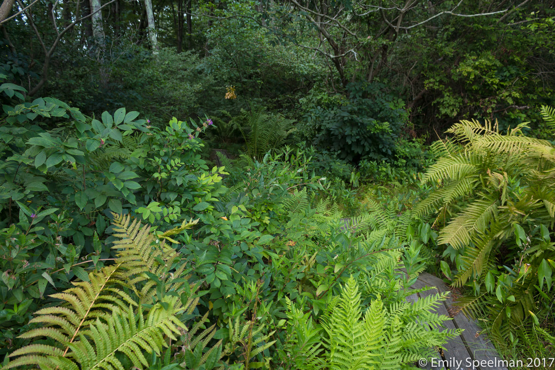
Nestled away among the corn fields of Tuscarawas County is the Beach City Wildlife Area. There's lots to do in this almost 2000 acre natural area, but we're going to focus on one teeny tiny magical section - Dundee Falls. I had never heard of Dundee Falls until one of my friends posted about it - I was intrigued, but then let it slip from my mind again. Then this summer while Noah and I were taking our Ohio Certified Naturalist Course through the Wilderness Center in Wilmot, we took a field trip to Dundee Falls. It was more beautiful than I imagined. Some more time passed until one morning I couldn't sleep so I decided to watch the sunrise over the rolling hills of the part of Ohio where Wayne, Holmes, Tuscarawas, and Stark Counties all come together. I was not disappointed. As the sun rose it warmed up the dew which took to the sky in ribbons of fog. From there it was just a few minute drive down some twisty unlined back roads to get to the trailhead at Dundee Falls. It's an unassuming parking lot, easy to miss if you're not looking for it, from there take the trail to the right and after a short jaunt you'll be at the first of the falls (considered the upper falls even though it's further south than the others). The sun was just beginning to make its way into the gorge, awakening the birds with a gentle ambient foggy light that appeared to glow from the gorge outward. Following the creek a little ways you can see all sorts of interesting rock formations and slump rocks, the hemlock trees verify the cool climate hidden below. Take the trail on the other side of the falls through the hemlock trees and follow it about 1.2 miles to get to the larger falls (lower falls or northern falls). There you can walk the creek and find beautiful smaller falls as well. It is a one-way trail so you'll have to follow your path back. Catching a glimpse of the fleeting moments between night and day are like being let in on a secret - like the Earth says "Yes, I see you, come watch how I make the magic." More info and a map of the area can be found HERE
1 Comment
While I love to travel and experience new places, there's nothing like going home to the parks you know so well, the parks who have shared their secrets with you and let you in on a world all their own. Trekking through these two parks you can hear a whisper in the air, it's quite subtle and if you weren't listening intently, you'd probably miss it. It's the whisper of a song about to grow much louder, the cicadas start off the orchestra and slowly it builds from there - the warm breeze, a choir of emerging fungi, the warm musty bassoon-like scent of decaying leaves - day by day adding more elements to the song until it ends in a fantastic crescendo where all the leaves, which have turned brilliant colors, come tumbling to the ground.
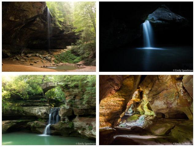
Yep, the gentle signs of fall are in the air. Hocking Hills, where does one begin, this is an area I've been visiting since I was a child, it is so very dear to my heart and I know I'm not alone on this. Every year millions of people travel from all over the world to experience the beauty that is this natural area. You'll find everything from waterfalls, cliffs, and caves. By observing the rocks you can travel through time and observe the history of Ohio.
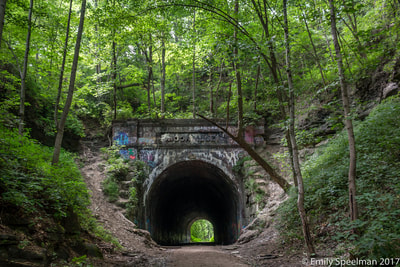
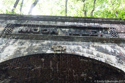
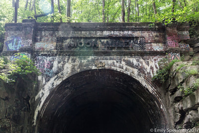
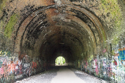
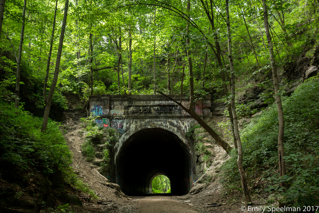
The first people to explore and establish in this area were of the ancient Adena culture over 7,000 years ago. More recently in the 1700s Native Americans would travel through these caves and hollows. In the 1800s white settlers began settling in the land and by the late 1800s it became a popular scenic attraction. In the 1920s the State began purchasing this land to preserve these natural features. The rocks tell us so much more than that. The highlighted features of the Hocking Hills complex are carved from Black Hand Sandstone and shale. This bedrock was deposited more than 350 million years ago as a delta in the warm shallow sea which covered Ohio at that time. The millions of years following, the uplift and stream erosion created the remarkable features you can see today. Sandstone varies in composition and hardness from softer, loosely cemented middle zone to harder top and bottom layers. The recess caves like those seen at Ash Cave, Old Man's Cave, and Cantwell Cliffs are all carved in the softer middle zone. Weathering and erosion widened cracks found in the middle layer of sandstone at the Rock House worked to create the unusual formation found there. When observing the rocks you can also see interesting features like cross-bedding, honeycomb weathering, and slump blocks. Although glaciers never reached the park areas, their influence can be found throughout the area in the form of the vegetation such as the towering eastern hemlocks, the Canada yew, and the yellow and black birch growing in the gorges. While we weren't able to visit all of the parks on this trip, we did see quite a few... Rock House, Conkle's Hollow, Old Man's Cave, Cedar Falls, and Ash Cave (Missing - Cantwell Cliffs, Whispering Cave) Click "Read More" to read about each place we visited and enjoy some of the photos we took along the way. This is a little different from our usual posts, although it is in the heart of Zaleski State Forest - a beautiful forested, hilly section of Appalachia in South East Ohio. No, this post is more about what use to be, what remains, and a little bit of what comes next... The History"It was the loneliest stretch of railway from Cincinnati to Marietta. In the 1800s, the land around the town of Moonville was covered in forestland for as far as they eye could see. There were sparse pockets of cleared land from the iron furnaces, small farms and coal mines, but traveling these tracks by train was like careening down a highway in a fast car at a hundred miles an hour and turning off the lights. It was dark and desolate and difficult to see. The engineers had to watch for cows and deer, chunks of trees and water flooding over their path. Add the tree canopy above that literally hugged the railway bed so it was like one, huge tunnel of black and you had a place all engineers simply dreaded to pass. That was Moonville." - excerpt from www.moonvilletunnel.net Moonville was established in the 1850s after Mr Coe sold part of his land to the C&M Railroad to cut an even and flat route through the rough Appalachian terrain. This worked in Coe's favor as his land was rich with coal and clay which we could then get to the market easier. From this train stop a small mining town was formed topping out at around 100 people in the 1870s. The train was both a blessing and a curse to this small town, providing a way to earn money and creating an easy walking path to get from town to town, however many lives had been lost by those entering the long dark tunnel or crossing the two narrow trestles over the nearby rivers. As resources and the economy dried up in the 1940s so did the small town and by the 1950s all that remained were a few abandoned houses. In 1988 the trains stopped traveling this route and the tracks were pulled up. The LoreEvery small town has its ghost stories, between the train and the deaths this former town has many. The one I enjoyed the most was The Ghost of The Engineer... "On a cold November night in 1880, Engineer Frank Lawhead was taking the dark passage from Cincinnati to Marietta. He would have no more time than to blink at a light bearing down on him before his life was stripped away from him. The dispatcher failed to notify the train there was a second train coming toward them on the tracks. The train he was driving along the Marietta and Cincinnati route through the tiny town of Moonville would take a headlong trip straight into another train coming along the same tracks. He died, most likely, instantly along with the fire man on board the train. The Fort Wayne Weekly wrote this on November 10th 1880: 1880 Frank Lawhead, Engineer Killed in Train Wreck Near Kings station in this county on Thursday last, Engineer Lawhead and Charles Krick, fireman, both of Chillicothe, were instantly killed by collision of freight trains, which, we are told, was the result of a mistake of train dispatcher. The trains were totally wrecked.(Athens Messenger, Thursday, Nov 11, 1880). The Fort Wayne Weekly November 10th 1880 That should have been the last of it. But not long after the engineer and fireman were killed, a ghostly form dressed in white began showing up along the tracks frightening the engineers running the route from Cincinnati to Marietta. Those riding the desolate route would see something shining in the distance, then a white form would appear. Just as quickly, it dissipated into the blackness of the forest around them. 1895 Chillicothe Gazette wrote the following: A ghost (after an absence of one year) returned and appeared in front of a freight at the point where Engineer Lawhead lost his life. The ghost is seen in a white robe and carrying a lantern. "The eyes glistened like balls of fire and surrounding it was a halo of twinkling stars" - Chillicothe Gazette, 17 Feb 1895 And to this day, visitors to the site still swear they see lights at night, find images of an engineer on their cameras." There's also said to be a ghost of the brakeman, the lavender lady, and the bully - again all can be found at www.moonvilletunnel.net The RemainsNow all that is left is the tunnel, the stories, and a 16 mile Rail-trail which runs from just outside of Zaleski, OH to just outside of Mineral, OH.
Zaleski is still the densest most unpopulated forest in the state and is quite stunning. If ghost stories aren't your thing, go for the scenery, it is lovely and oh so quiet! What is it? Who built it? How old is it?
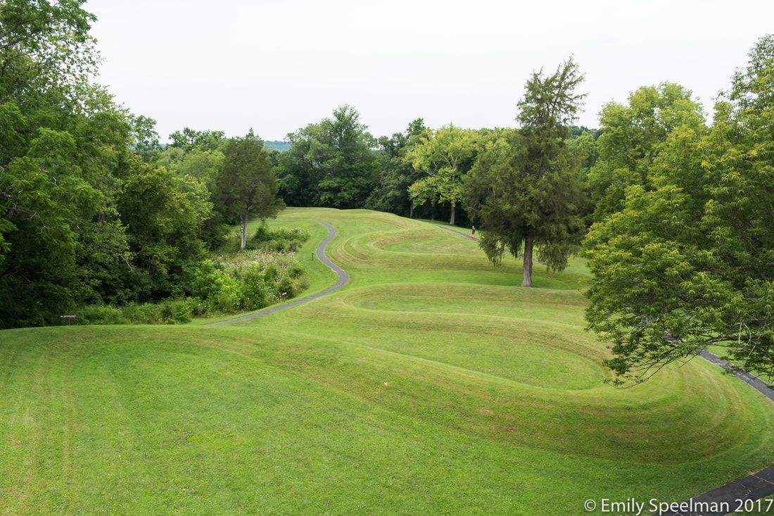
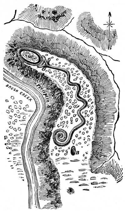
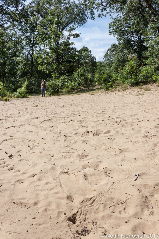
No one is entirely sure. Although there are a great number of theories about this ancient animal effigy mound located in Adams County in Southern Ohio . Based on carbon dating and using the neighboring burial mounds as clues, it's believed that the mound was formed by the Adena Culture (800 BC - 100 AD), although with the lack of artifacts with which to identify for certain, it has also been credited to builders from the Fort Ancient Culture (1000 - 1650 AD). Theories, as they do, sometimes get out of control and there are some people who claim aliens are the ones who built the mound... yep. Why it was built is still unclear, but there are plenty of theories on that as well. Perhaps it was to aid in moving those from death to the next world. It could have been a site of ritual or sacred ceremonies. The serpent shape is very symbolic representing death and rebirth - consider the shedding of the skin, the venom while deadly is also used in the antivenom, it has been called both the devil and a healer - it is the ultimate balance . Both the head and the tail of the serpent overlook the steep ravine to the west, the head aligning with the sunset of the Sumer Solstice. In the serpent's mouth is thought to be an egg, although some think it may be an eye or perhaps the sun. I like to imagine myself there thousands of years ago, all the trees would be gone, the view from on top of the cliff where the serpent lies would be a stunning overview of the surrounding areas, what would I see, what would I find important, how would I show my thanks to the Gods/Goddesses/Universe? When walking this sacred area a feeling of wonder fills the air. A place that is bigger than your current world, to time travel and go beyond yourself, to walk in meditation pondering that which we can not know. This site is well worth the visit. The town of Yellow Springs is a culturally diverse oasis tucked away in Eastern Ohio. It was named for the spring which was discovered around 1800 the water from which was said to have healing properties. Around the spring the town built up as a health resort building hotels, spas, boarding houses, a tavern, and Antioch College. Once the railroad moved in it became the center of trade and recreation for the region. Today the spring and the name exists but all the spas, boarding houses, and hotels are all gone as well as the rail road which has been converted into biking trails. People visit today for the eclectic shopping, dining, and recreation - as it is adjacent to a considerable numbers of outdoor activities. A mile out of town is the Glen Helen Nature Preserve, home to the yellow springs for which the town was named for. There are also limestone cliffs, overhangs, and waterfalls to be found throughout the 20 miles of hiking trails. When we arrived in town, all the shops were closed (town basically closes from 6pm - 11am) so we decided to check out the springs. Down the great rock stairs we went, over a bridge, and down the path. We came across some really awesome rock formations, and a lot of noisy people. We made it to the springs which were very unique - the rocks stained from the iron rich waters. But rather than continuing on to see more of the park, we turned back, it's not a place to go if you're looking for peace and quiet (at least that was our experience). I have been wanting to come here since I joined one of those Facebook groups dedicated to specific nature topics - i.e. wildflowers of Ohio, birds of Ohio, etc. The plants that people would share from here were so unique and diverse I just had to go see it for myself! So glad I did! Cedar bog is actually a fen (the water drains from this wet area where as bogs retain their water) located just south of Urbana, Ohio - the largest in the state. This natural area is home to more than forty rare, endangered, and threatened plants and animals. It ranks the highest of any site among all others in the state on the Ohio Floristic Diversity Index for its great diversity of plants. We arrived on a hot afternoon in July, understandably we were the only car in the lot that day. From there we paid our $5 admission and hit the boardwalk. The plants on the way to the woods were abuzz with bees and butterflies, the giant ragweed was getting huge. We made it into the shade of the forest, a blanket of skunk cabbage lined the forest floor. Teeny-tiny and easy to miss I was able to find a well hidden club-spur orchid (the 2nd orchid I've ever found in the wild!). The boardwalk is a nice almost mile walk, from the woods it opens up into a sedge prairie where we found sundews, bladderwort, rough-leaved cinquefoil, and a great number of, you guessed it, sedges! Then back through the cedars to loop the trail back around to the beginning. This is an incredible place to go explore, we ended up staying there about two hours. We will definitely be making a trip back in April/May for the wildflower display! Hidden underneath the rolling farmland of eastern Ohio is America's most colorful cavern - Ohio Caverns. At a cool 54 degrees year round, Ohio Caverns is a lovely place to beat the heat while learning about the geology of the state. They offer a variety of tours as well as provide above ground 'mining' for younger crowds. The cavern was discovered by a young farm hand who would notice how a low spot in the land, after a heavy rain, would drain the water faster than other areas on the farm. To find out how it all came together, I recommend taking the historic tour. What makes a cavern different from a cave? One important feature - caverns have no natural entrances. How are caverns formed? Glacial melt would cut rivers underground, ground water seeps through the soil gathering minerals from rocks, slowly stalactites build up over thousands of years. What is the difference between stalactite and stalagmite? Stalactites form from the upper rocks - holding 'tight' to the ceiling. Stalagmites build up from the dripping stalactites overhead - being brave and showing their 'might' and courage to stand under a stalactite. We took the natural wonders tour - it was getting ready to leave just as we arrived! The tour takes you through about a mile of the most stunning display of rocks and formations, the interesting mineral content in the surrounding rocks makes this the most colorful cavern in the US. Being an easy day trip from anywhere in Ohio, I recommend checking it out. Tucked up in the far north-west corner of Ohio stands a forest comprised of 100 acres of virgin timber and one of the most well preserved remaining sections of the Great Black Swamp. This is Goll Woods State Nature Preserve, just beyond Archbold, OH. The Goll family immigrated from France in the 1830s, settled this land, and kept this section of land untouched and in the family until the 1960s when the family gave the land to the State of Ohio to keep as a Preserve. This incredible area is home to trees aging up to 400 yrs, with one of the oldest oak trees dying of old age in 2006. Along with the great old trees, this preserve boasts a fantastic spring wildflower display. On the property there is still the original homestead and the family cemetery - home and barn are being restored and will hopefully become an education center for the area. We arrived in the early evening, it had been a hot day so a walk in an old dense forest sounded like a nice cool-off. We were a little surprised there were no other cars in the parking area, but as far out in the middle of nowhere as it was it made sense. We started down the trail debating if we wanted to do one of the longer trails or just keep it to the short one (mind you this is still day one, we had just arrived from oak openings and Magee that morning). About 50 ft into the park our decision had been made to take the short route. Knowing ahead of time we'd be walking in a forested wetland we took proper precautions - long pants, heavy duty bug spray, the works - we were not prepared for the type of mosquito that made the great black swamp its home! These were the fastest, most cunning, and aggressive mosquito we've ever encountered - as we speed walked the mile trail we could see an actual cloud of mosquitoes following us, completely undeterred by the bug spray. We would sacrifice ourselves from time to time though, as the majesty of the trees would captivate us. These trees are truly giant, and to think just how much has happened in their lifetimes, it's humbling. I was able to capture a few shots of the trail, the blurred one I feel captures our experience best though. I would definitely like to come back here, but in early spring for the wildflowers and before the mosquitoes. Reading an article from the local news paper about the park, this quote stood out to me "In the summer, the trails are especially empty because of a vicious tide of mosquitoes that sweeps through the woods." Lesson learned! The Oak Openings area has been called "One of the 200 'Last Great Places on Earth'" by the Nature Conservancy, and rightly so, this sandy region that is part of the Toledo Metroparks is a rare and unique ecosystem known as an Oak Savanna. Let's start with some Q & A then we'll get into the cool things we found... What is an Oak Savanna? An Oak Savanna is commonly defined as a plant community where trees are a part of the landscape but their density is so low as to allow grasses and prairie vegetation to dominate the community. Another way to think about that would be by gauging the tree canopy density - I know, that sounds complicated, but stick with me here - we'll pretend it's noon in midsummer, if you were in an oak savanna there would be less than 50% shadow coverage or half the ground would be in sunlight, if there was more than 50% shadow coverage you're in a woodland or forest. Why is it so rare? Early travelers in the Midwest would remark on how "park-like" these areas were, with the large trees and easy to traverse grasses. This made these areas easy to inhabit while settlers moved west and why many of these areas have disappeared. Why don't these areas become woodlands? The oak savannas of the midwest are closely linked (ecologically and topographically) to the native prairies of the area - these are the types of plants that grow well in these areas. However, as woodlands encroach on the savannas, and as leaf litter builds up, it is common practice to perform routine managed fires (when the midwestern savanna stretched from Texas to Canada, this would occur naturally through lightning strikes). Oak trees are equipped with unique fire-resistant qualities allowing the grasses and other trees and shrubs to be burnt down while the oaks remain fine. It's also been found that fire, while it will burn oak saplings to the ground, actually help the saplings grow deeper roots which will then allow the sapling to grow back stronger. Alright, now tell me about this particular savanna - Oak Openings. So, the Oak Openings (Toledo Metropark) takes its name from the surrounding oak openings region, which is 23 times larger than the park itself - that is huge as the park itself is about 5,000 acres!! The area is incredibly diverse - prickly-pear cactus, wild lupine, and sand cherry can be found on the hot sand dunes while just yards away there will be delicate orchids blooming in the low, wet swales. Back thousands of years during the Late Wisconsin Period the glaciers flattened and leveled the ground in the area all the while depositing clay till. This formed the basis for the "Great Black Swamp" south of the Maumee River. When the glacier melted back, it blocked the outlet for Lake Erie, so all the meltwater deposited sand into the shallow pro-glacial lakes. From Napoleon, OH to west of Detroit, Michigan it is known as the "sand belt". When the water receded, the sand was blown into dunes sitting on top of the impervious (non-draining) clay till - this is how the area can have such diversity so close together - the water flows through the sand leaving the sand dry but with the clay base the water flows to the adjacent poorly drained swales making water available to plants and animals in the Oak Openings. What did we see? When we arrived, I don't think either of us had any idea of just how big this park was - turns out there's over 50 miles of trails through a variety of different habitats - so we opted for the one that would work best for the amount of time we had - the Sand Dunes (red) trail. We started the journey through a cool coniferous forest that led us to the breath-taking openings. I still can't find the words to describe what it was like there, it was cool and covered but bright, you could see through the trees for what felt like miles, the ground, while covered, maintained the comforting safe visibility that I'm sure the settlers found to be ideal (no giant monsters hiding in those woods!). The covering - to my surprise - was mostly light and airy ferns (makes sense now that I know about the clay, sand, and water, and how they work together). The oaks in this area were huge! As we continued on, we came to the sand dunes where we may have lost the trail and may have wandered further than we should have but we came across the most interesting scene.
A very awesome discovery to be sure! From there we back-tracked until we found the trail again and wandered back through low wetlands, forested areas, and savanna. This is an area I'd like to spend more time, see it through the different seasons, watch as it comes back after a burn. As we left, we stopped by a different trail where during the Great Depression WPA workers planted stands of isolated pine and spruce. I highly recommend checking out this area to everyone whether interested in birding, flowers, geology, or just taking a nice stroll - this is the place! Just north of Oak Harbor along the Lake Erie coast is the Magee Marsh Wildlife Area. This expanse of marshland was originally known as a great waterfowl hunting area (you can find an array of decoys dating back to the 1800s in the Bird Center) but now is known world wide as one of the best birding areas in North America, especially during the spring migration. As the birds travel north to their breeding grounds, they pause to gather strength to cross Lake Erie and continue on to Canada. Magee provides the perfect environment for the birds to wait, ample food, and shelter with the variety of shrubs - to old tall trees. Although we arrived outside of the birding season (March - end of May is best), we still found a good number of birds - most new to my list this year! When we arrived we stopped by the Bird Center to get a map and a feel for the area, the birding center had a great display of stuffed birds - you don't realize just how big a bald eagle is until you're standing next to it! Looking at the map we were impressed by the number of trails that we could take, there's also blinds out in the field where you can go and wait without standing out like a sore thumb, we opted to explore the "famous" boardwalk that takes you through tall woods, shrubby areas, and right by open marshy wetland areas. Here we saw a couple of warblers, wrens, a white pelican flew over (!!!), a cuckoo, brown thrasher, kestrel, great egrets, ruby throated hummingbirds - and this is in the slow season in the middle of the day! To get back to our car we took the new(?) beach trail along Lake Erie where we found a few more birds: bald eagle, woodcock, and some sort of piper or plover - couldn't get a good view. Half a day was not nearly enough time to explore this area and all it has to offer, we will be making a point to return with a long weekend in mind, there's just so much to see! Also right next door is the Ottawa National Wildlife Refuge and Crane Creek State Park! What a great time we've had exploring some -new to us- natural areas of Ohio. We traveled from the north to the west to the south and back - as we've spent a good amount of time in the middle of Ohio.
Where did we go? - Magee Marsh - Oak Openings - Goll Woods - Ohio Caverns - Cedar Bog - Yellow Springs - Serpent Mound - Zaleski State Forest - Hocking Hills What did we see there? You'll have to follow along this week to learn about each of these places and all the great things we did/saw at each one! |
AboutSince 2015 we have been exploring and sharing all the amazing things we’ve found in nature. AuthorEmily is an Ohio Certified Volunteer Naturalist who is most often found out in the woods. Archives
March 2024
Categories
All
|
 RSS Feed